Support and enabling the Kingdom's Vision 2030 goals and other national strategies
Enhanced engagement for utilization of integrated geospatial information
Support the transformation and the national digital economy
Utilization from the best applicable global practices in the field of geospatial information
Accelerating economic growth, improving productivity and technological advancement in all sectors
Encouraging and supporting innovation and creativity in the geospatial information sector
National capacities building and skills and increasing employment opportunities in the sector
Protecting the kingdom's resources and environment
Support the national sustainable development initiatives
strengthening and enrichment the national geospatial platform to be the national source for the information
Using Key Performance Indicators (KPIs) and Critical Success Factors (CSFs) for the Geospatial Roadmap
Consideration will be given to aligning the strategy with the IGIF
A strategic guide to develop and strengthen national geospatial information management endorsed by the United Nations, and was developed in collaboration between the United Nations and the World Bank, many countries (including Saudi Arabia represented by GASGI) in addition to experts contributed in the development of
IGIF.

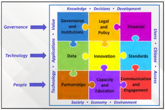
The Framework is anchored by nine (9) strategic pathways, and also is a mechanism for articulating and demonstrating national leadership in the field of geospatial information, and the ability to take positive steps.

Solving the Puzzle 13 Dec 2019 GLOBAL CONSULTATION

SP1 - Governance and Institutions 13 Dec 2019 GLOBAL CONSULTATION
SP2 - Policy and Legal 23 Feb 2020 GLOBAL CONSULTATION
SP3 - Financial 19 Jun 2020 GLOBAL CONSULTATION
SP4 - Data 10 Jan 2020 GLOBAL CONSULTATION
SP5 - Innovation 4 Jul 2020 GLOBAL CONSULTATION
SP6 - Standards 7 Apr 2020 GLOBAL CONSULTATION
SP7 - Partnerships 21 Feb 2020 GLOBAL CONSULTATION
SP8 - Capacity and Education 19 May 2020 GLOBAL CONSULTATION
SP9 - Communication and Engagement 29 Feb 2020 GLOBAL CONSULTATION
Integrated Framework for Geospatial Information
Future trends in geospatial information management: the five to ten year vision (3rd edition)